Carte geographiqve de la Novvelle Franse faictte par le Sievr de Champlain Saint Tongois Cappitaine Ordinaire povr le Roy en la Marine
Dublin Core
Title
Carte geographiqve de la Novvelle Franse faictte par le Sievr de Champlain Saint Tongois Cappitaine Ordinaire povr le Roy en la Marine
Subject
Map of New France by Samuel de Champlain
Description
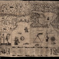
Champlain's detailed map of 1613 was produced at a time when France was markedly intensifying its commercial interests as well as seeking the North West Passage to Asia. The map's utility as a navigational tool is explicit in the presence of a compass rose and rhumb lines that reflected Champlain's detail in recording his own first-hand experiences. Indeed, the inscriptions in the upper corners of the maps describe how the map was made for sailors who used French compasses uncorrected for magnetic deviation. Champlain's rationale was explained by the sailing times that could be lost by ignoring such potential errors with further advice that ships' compasses should be adjusted once the Grand Banks were reached. Notably, the map adopts the new convention of consolidating Newfoundland (but still heavily indented) into a single triangular form.
The map also serves to depict regional flora and fauna as well as illustrate indigenous peoples. Of the various marine life distinguished are cod (a 'molue' placed beyond the southern reaches of 'le Grand ban'), dogfish, bullfish, bass, garpike, sturgeon, horseshoe crab, and salmon (positioned by Newfoundland's south-western inshore fisheries) as well as marine mammals such as the sea-lion and the whale. The sea is implied to be as much as bounteous an asset as the land (although the act of fishing is absent) and with individual ships (rendered differently in size, orientation, and even shown firing artillery) also punctuating the map, there is little by way of empty space. The focal point of the cod fishery in the Grand Banks is rendered in a fine stipple with localised spraying waters indicating the navigational hazard of the Virgin Rocks - 'les miqueles rochers' - off Newfoundland's southern tip. The map significantly broke from previous conventions that the Grand Banks were uniform in shape or breadth and that even within the Grand Bank itself there was variable depth. Indeed, four individual banks are distinguished ('ban neuf', 'bangeureaux', 'ban au vert', and 'le Grand ban' with smaller areas stippled near 'banguereaux' in addition to the accurately crescent shaped 'ille de sable' complete with lighthouse indicating that it was not only a potential hazard for local fishermen but also for voyagers on direct routes between Europe and North America.
Champlain's map provides no indicator of settlement on Newfoundland (contrary to Nova Scotia and rest of the North American coastline) but permanent English settlement would have been at a very embryonic stage at this time even if Champlain was aware of it. Greater clarity and scale are provided throughout than earlier maps as exemplified in its depiction of 'ille de bacallos' near Newfoundland's westernmost point. Champlain also authored an account describing his experiences that place his Grand Banks cartography in further perspective. He explains how its shape came to be drawn from the 'innumerable soundings' of 'all former seamen' whereby a soundinglead was prepared at timed intervals to ascertain that 'when he is on the [Grand] Bank he will find 45, 40, 35 and 30 fathoms, a little more or less according to latitude…'. For further confirmation an 'infinite number of birds' followed the fishing vessels to scavenge fish entrails returned to the sea. The very knowledge of the Grand Banks not only transcended its utility as a fisheries resource but also in Champlain's opinion was 'the cause of so many vessels not being lost, as they would be if it were not there, since it enables the seaman to correct his reckoning.' Champlain's cartographical portrait hinted at how the Newfoundland fisheries were more expansive (to the south and further offshore) and could be more precisely delimited than predecessors had suggested.
Creator
Samuel de Champlain
Source
unzipped from John Carter Brown Library - http://jcb.lunaimaging.com/luna/servlet/detail/JCBMAPS~1~1~4960~115900199:Carte-geographiqve-de-la-Novvelle-F?sort=normalized_date%2Cfile_name%2Csource_author%2Csource_title&qvq=q:champlain;sort:normalized_date%2Cfile_name%2Csource_author%2Csource_title;lc:JCBMAPS~1~1&mi=4&trs=36#
Publisher
Trinity College Dublin
Date
1612, Paris
Contributor
Dr Kieran Rankin
Rights
Creative Commons
Relation
John Carter Brown Library
Language
English
Type
Map
Files
Citation
Samuel de Champlain, “Carte geographiqve de la Novvelle Franse faictte par le Sievr de Champlain Saint Tongois Cappitaine Ordinaire povr le Roy en la Marine,” NorFish Platform: Databases & Cartography Hub, accessed December 22, 2024, http://cehresearch.org/norfishplatform/items/show/5.

