La Nuova Francia
Dublin Core
Title
La Nuova Francia
Subject
Map of New France by Giocomo Gastaldi
Description
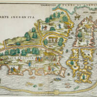
In 1556, a dedicated and regional woodcut map titled 'Nuova Francia' [New France] attributed to Giacomo Gastaldi held further aesthetic appeal with vivid vignettes of inhabitants not only dancing and hunting on land but also strongly indicating the prevalent opportunities for fishing along with a significant rendition of the Grand Banks.
Gastaldi was associated with Giovanni Battista Ramusio, secretary to the senate of the Venetian Republic (by then a formidable trading power and a hub where geographical science was flourishing), and he served as its official cosmographer. The map is contained within the third volume of Ramusio's Navigationi et Viaggi [Navigations and Travels] (1556) published as part of a series of complementary mapping which was then one of the most comprehensive to be produced before Abraham Ortelius' seminal atlas of 1570. In its preface, Ramusio recorded how he was 'exhorted' to include new mapping of the New World in the Ptolomaic style 'but including whatever has become known up to the present, namely the coasts added in navigators' charts by Spanish pilots and captains.' The popular impact of the publication to a receptive travel literature readership was such that it was translated into other languages and necessitated reprints. The map reflects the discoveries of Jacques Cartier's voyages and those of Giovanni di Verrazano who was seeking a passage to Asia on behalf of Francis I of France. It has been suggested that by integrating information from both Cartier and Verrazano the map compounds original distortions and errors.
Similarly to Rotz, the map also represents the Grand Banks of Newfoundland as an elongated arcing band (but comprised of irregularly sketched dashes and minute circles to indicate a sandy texture) and includes a quadrilateral rendering of 'Isola della rena' - Island of Sand - Sable Island's precursor. Also the fragmented group of islands south of Labrador confirmed the prevailing concept of Newfoundland as an archipelago but the island named 'Baccalaos' is noticeably elongated compared to Reinel's and Rotz's versions. Apart from the physical geography, the map is replete with illustrations that depict cultural and political dimension, attesting to a landscape and seascape of dynamism and vitality, in which fishing features very strongly.
Among the fish related vignettes are a fish appearing to have been hooked on a line (handlining) from an unmasted two man crewed boat with another two man crewed boat using a rod (see figure 3b); a pair of fish hanging to dry from a bar suspended between two trees (see figure 3c); examples of gill-netting and sail-assisted drift netting (see figure 3d); and, various individual depictions of other fish and other marine life surfacing the water (as well as mythical creatures). A number of vessels are illustrated that are variably sized, crewed, masted, with sails either furled or unfurled. The political dimension is inferred from the Portuguese quinas escutcheon on in the upper right corner of the map with it also appearing on an unfurled sail nearby as well as a pair of ships in both lower corners of the map having sails adorned with French fleur-de-lys.
The map would have served as an enticing prospectus for enterprise as well as invoking a frontier spirit. It depicts bountiful fish resources while also finding recourse for imaginative creativity to include winged mythical beings occupying the northern fringe of Newfoundland labelled the 'Island of Demons' [Isola de Demoni] as well as the mystery of a large blank tract 'Parte Incognita'. The vignettes of fishing (each positioned inshore from the Grand Banks) alongside the map's representation of the submerged physical maritime topography acted to reinforce the reputation of the Grand Banks' rich fishing grounds given its wide dissemination in contrast to the limited readership the Rotz Atlas manuscript would have had. Such mapping was also indicative of Italian influence in exploration (Verrazano was an Italian serving the French monarch) as well as cartographical expertise blending with French enterprise. Following Gastaldi's prolific output, which was based on an assiduous aggregation of knowledge, a succession of cartographers would have been influenced throughout Europe.
Creator
Giocomo Gastaldi
Source
http://collections.mun.ca/cdm/singleitem/collection/maps/id/97/rec/3
Publisher
Trinity College Dublin
Date
1556, Venice
Contributor
Dr Kieran Rankin.
Rights
Creative Commons
Files
Citation
Giocomo Gastaldi, “La Nuova Francia,” NorFish Platform: Databases & Cartography Hub, accessed December 22, 2024, http://cehresearch.org/norfishplatform/items/show/6.

