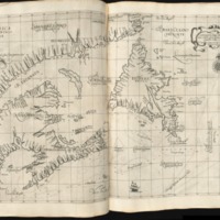
Carta particolare della terra nuoua con la Gran Baia et il Fiume Grande della Canida
Dublin Core
Title
Carta particolare della terra nuoua con la Gran Baia et il Fiume Grande della Canida
Subject
A specialised technical map of the Newfoundland region was produced by Robert Dudley in Florence as part of his c.150 marine chart atlas - Dell'Arcano del Mare [Secrets of the Sea] - a title acknowledging that cartographical details were regarded as trade secrets.
Description
This particular map has been termed 'one of the most important maps of the region ever produced.' Its status is more remarkable given the decades-long dominance of the Dutch sea atlases, the quality of its production (over 12 years in preparation as claimed in the atlas preface), and that it pioneered the inclusion of non-European dedicated sea charts. The entire atlas heralded an advance on previous work as it contained more coverage of the world, adhered to Mercator's ground breaking projection with an intersecting graticule indicating latitude and longitude - thereby indicating the shortest distance between two points on the world. Its technical utility extended to denote information (with resort to the ornate baroque italic calligraphy supplied by the engraver Antonio Francesco Lucini) as to currents, prevailing winds, magnetic deviation as well as quantified soundings (another crucial innovation). Yet, despite its undoubted utilitarian purpose, it has been opined that the atlas' promotion by its dedicatee, Grand Duke Ferdinand II of Tuscany, was politically motivated so as to award it as a gift to his foreign counterparts.
Several banks and sand bars are rendered on the map, each delimited by double dotted lines. The Grand Bank itself is a large winged expanse tapered by northern and southern flanks indented by semicircles, one of which contains crosses that accord with the Virgin Rocks hazard and perforated by smaller doubled dotted lines indicating uneven and shallower depths. In contrast to Champlain's rendering, the Grand Bank curves in a gentle arc eastward from Newfoundland. There are numeric fathom soundings as liberally shown elsewhere on what amount to a submerged chainof plateaus. There are stylised inscriptions such as 'Corrente Verso Maestrale' [Current to the [northwest] mistral [wind]] - (probably indicative of the Labrador current) ; 'L'Venti Sono spesso verso Ponente' [The winds are often westerly] ; 'laria fredda e asciutta [The cold and dry air]; 'Seccangna Lunga'[Long Bank]; and, 'La Gran Banca o Seccagna di Terra Nuova dove si pescano li merluzi' [The Grand Bank of Newfoundland where cod is caught].
Although known for heavily inscribing the coasts with nomenclature, Dudley was liable to fill otherwise empty space with different versions of the same name - e.g. 'G. di Bacalao' and 'B. di Bacalao' in addition to 'I. Bacalao' - with the suspicion that they were inserted to balance the map's appearance but this example uses more nomenclature than his other maps, especially on Newfoundland's western flank. The nomenclature frequently compounds Italianized English and French names. However, given the maritime emphasis, this is at the expense of showing much in the way of settlements. There are a few geographical curiosities on the map such as the pronounced exaggeration of Avalon peninsula compared with the rest of Newfoundland which appears to derive from charts of the Atlantic which Dudley probably accessed at his Florence base.
Creator
Robert Dudley
Publisher
Trinity College Dublin
Date
1647/8
Contributor
Dr Kieran Rankin
Rights
Creative Commons
Relation
http://www.leventhalmap.org/id/17602
Format
Map
Language
Italian
Type
Map
Files
Citation
Robert Dudley, “Carta particolare della terra nuoua con la Gran Baia et il Fiume Grande della Canida,” NorFish Platform: Databases & Cartography Hub, accessed December 21, 2024, http://cehresearch.org/norfishplatform/items/show/2.

