August 2017
by Dr. Kieran Rankin
The Oosterscher Zee map by Jan van Hoirne is one of the earliest surviving examples of north European sea charts to represent fishing. (See Figure 1). The woodcut map was discovered in around 1950 in the archives of the Rijksarchief in Groningen, Netherlands, where it remains and can be viewed to this day.
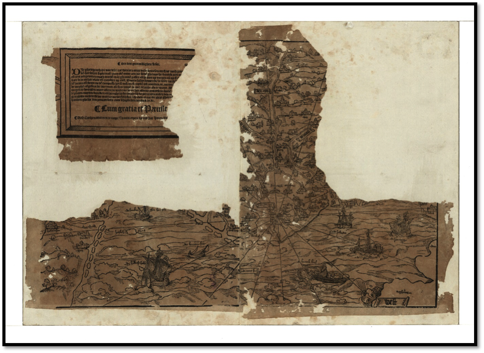 Figure 1: The ‘Oosterscher Zee’ map by Jan van Hoirne (Antwerp, 1526)
Not a great deal is known about the map maker, Jan van Hoirne, himself, although the individual has also been also known under different variations of the name including: Johannes à Hoorn [or Hoirne or Horen]; Ioannes à Horn; Jan van Hoirne; Jan de Beeldesnyder; and, Jan de Beeldesnyder van Hoorn. Hoorn is a town in the province North Holland. (The town’s name was appropriated for one of the world’s most famous headlands - Cape Horn). Located 35km north of Amsterdam with a harbour on the Netherlands’ large and distinctive shallow bay, the Zuiderzee, Hoorn eventually became an important base for the Dutch East India Company in the seventeenth century. The significance of Hoorn to the map is emphasised with its location serving as the epicentre of the map’s compass. (See Figure 2).
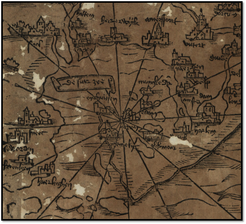 Figure 2: [Excerpt of town of Hoorn, North Holland,
assumed home of the map’s maker, Jan van Hoirne,
from] The ‘Oosterscher Zee’ map by Jan van Hoirne (Antwerp, 1526)
‘Beeldesynder’ literally translated means ‘image maker’ [?] but in this context probably meant ‘picture engraver’. It has been assumed that Jan was the father of Joost Janszoon Bilhamer [or Beeldsnijder or Beelsnyder] (c.1541-1590) who was a prominent architect, sculptor, engraver, and cartographer. Of near contemporaneous sources, a map titled ‘Germania Inferioris Tabulam’ published in Antwerp is attributed to Ioannes à Horn is cited as a source in Abraham Ortelius’ famous atlas ‘Theatrum orbis terrarium’ of 1570 and there is evidence in the State Archives in Brussels of a privilege being granted to Jan de Beeldesnyder of Antwerp to print a map of the ‘Oosterscher zee’ [the Baltic] in 1526.
The surviving map comprises three fragments. The top of the map is oriented in a south-easterly direction and the surviving territorial coverage extends over two sheets covering western Jutland, the Frisian Islands, a stretch of the interior alongside the lower courses of the rivers Rhine and Maas (as far as Koblenz and Maastricht respectively), slivers of northern France, and the south east of England. The content of the map (as well as its ascribed title ‘Oosterscher Zee’) suggests that two additional sheets would in all probability have also included eastern Denmark and the Baltic Sea, thus implying an original map of substantial size – c.380 x 1140mm.
A third surviving fragment consists of a bounded legend of the map. (See Figure 3). Written in Dutch with a Gothic font, it is torn and thereby incomplete but some meaning can be gleaned with regard to technical advice to mariners in interpreting distances and maritime hazards, plus the fact that the map may be purchased from the cartographer himself – ‘Jan Horen’ - in Antwerp. Given the strong maritime themes included, it may be fair to conjecture that that the cartographer had personal maritime or trading experience.
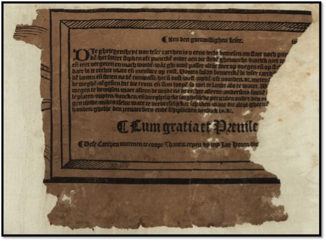 Figure 3: [Excerpt of incomplete map legend, from] The ‘Oosterscher Zee’ map
by Jan van Hoirne (Antwerp, 1526)
Given the map originates from 1526, it supplies a remarkably early visualisation of how fishing was conducted in the North Sea in the early sixteenth century. The sea is adorned with seven individual vessels ranging in shape and size. One of the vessels located between North Holland and East Anglia illustrates a method of fishing and the physical conditions in which it took place. (See Figure 4). The surrounding waters are shown to be in swells with a classical cherubic rendition of a wind of a prevailing western origin. [Insert – transcription/translation of boat label inscription, technical description of vessel and nets]. The level of detail of the vignette points to the significance of fishing to Dutch interests with the map as a whole hinting at the importance of a growing trade between North Holland/Amsterdam with the Baltic at this juncture of the sixteenth century.
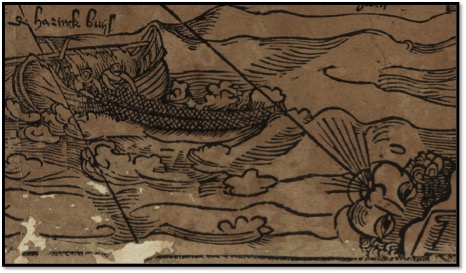 Figure 4: [Excerpt of fishing boat in the North Sea, from]
The ‘Oosterscher Zee’ map by Jan van Hoirne (Antwerp, 1526)
Overall, although this particular map is frustratingly incomplete, it not only demonstrates the value of cartographical evidence in exhibiting the extent of contemporaneous maritime and fishing knowledge but also helps to visually corroborate and contextualise other documentary sources just as the ‘Fish Revolution’ was gathering momentum in the sixteenth century.
Bibliography:
Bert van’t Hoff, ‘Jan van Hoirne’s Map of the Netherlands and the ‘Oosterscher Zee’ Printed in Antwerp in 1526,’ Imago Mundi, 11 (1954): 136.
Robert W. Karrow, Jr., Mapmakers of the Sixteenth Century and Their Maps: Biobibliographies of the Cartographers of Abraham Ortelius, 1570. (Chicago, 1993).
About the author:
Dr Kieran Rankin is a Political and historical geographer, currently working as Research Fellow on the ERC Advanced Grant funded 'NorFish - North Atlantic Fisheries: An Environmental History, 1400-1700' project. Research interests: Political geography, international boundary studies, historical cartography, the Middle East, and modern Irish and British history. Currently serves as the digital journal manager for both the Journal of the Statistical and Social Inquiry Society of Ireland and the Economic and Social Review.
Full bio »